HIGHWAYS HERITAGE WALKS
HEAD OF ROSEDALE – CROSSES , BOUNDARY STONES, PANNIER WAYS AND EXTENSIVE VIEWS FROM THE TOP OF THE NORTH YORK MOORS
Walk Length: 2 miles. Allow 2 hours.
Grade: Easy; the route is split evenly between roads and tracks, the latter can be boggy. Not suitable for mobility-impaired or young children. Not recommended in poor visibility.
Grid Reference: GR NZ 6771701916
Postcode: YO62 7LQ (Lion Inn at Blakey ; nearest building 2 miles to the south !!)
Public transport: Moors Bus ; M3 (from Helmsley) and M6 (from Pickering) on Sundays and Bank Holiday Mondays April to October.
Parking: in small car park at road junction at Rosedale Head.
Description
The route starts from a car park near one of the highest parts of the North York Moors at Rosedale Head at nearly 1400 feet above sea level. The first cross, Young Ralph, is quickly visited, followed by Old Ralph and then White Cross, better known as Fat Betty. We then set out on a track across the head of Rosedale, visiting two parish boundary stones on the way, marking the ancient division of Westerdale and Spaunton parishes. Finally, we meet Margery Bradley, another boundary marker that uses a large natural boulder to confirm the boundary of the estate of Thomas Duncombe , 17th century owner of the Honour Of Helmsley. A short walk then takes us back to the car park.
Route Instructions
1. Young Ralph.
2. Old Ralph.
.jpg)
3. White Cross (Fat Betty).
4. Rosedale Head East Stone
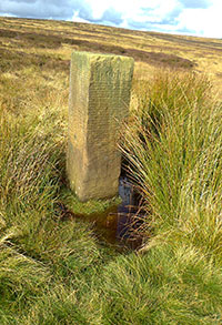
5. Rosedale Head West Stone.
6. Margery Bradley.
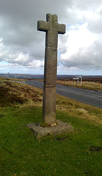
1. Turn left from the car park and then immediately right onto the Hutton-Le-Hole to Castleton road. Follow this for 1/3rd mile until you see Young Ralph, a 10 foot high cross, on the left-hand side of the road. 1 The earliest records date back to the 12th century whilst a 13th century charter records the cross as a boundary marker for Pickering Lythe Manor. In 1550 the cross is recorded as having been made of wood whilst the current edifice was probably erected in the 18th century. One local legend tells of the cross being erected on the site where a poor traveller died from exhaustion. His body was discovered by a local Danby farmer called Ralph who decided to erect a cross on the site to guide travellers across the moor. In 1974 Young Ralph was adopted as the emblem of the North York Moors National Park.
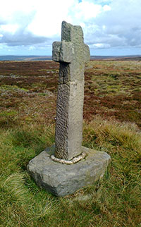
2. From Young Ralph, follow a thin path across the moor in an ESE direction for 350 yards. Almost immediately, you will begin to see Old Ralph on the horizon. Do not attempt this section in poor visibility. 2 Old Ralph is mentioned in the Guisborough Charters in the early 11th century and may have been named after Bishop Ralph of Guisborough Priory which was given extensive grazing rights in the area at this time. He was also related to the de Brus family of Danby Castle. Another legend connects the cross to a dalesman called Ralph who attached himself to Rosedale Priory helping with the livestock and maintenance. An R is carved into the base whilst the shaft is adorned with C D (Charles Duncombe) and the date of 1708.
3. From Old Ralph, re-trace your steps to Young Ralph and then back to the car park. Continue along this road in an easterly direction for almost ½ a mile to White Cross (or Fat Betty !!). 3 The cross stands on the boundary where the 3 parishes of Danby , Westerdale and Rosedale meet and also on an old pannier (packhorse) route that connected Rosedale with Danby and Castleton. The cross is possibly of Norman origin comprising a small wheelhead set into a large stone base. As with the earlier crosses, this one has legends attached. Firstly, Betty takes her name from one of the Cistercian nuns at Rosedale Priory, sister Elizabeth. Because they wore undyed gowns of wool they were known as “White Ladies”. The second is based around the story that Betty was a farmers wife from Castleton who fell from her husbands cart one misty night. When he retraced his route across the moor, all he could find was the large squat stone now known as Fat Betty.
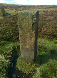
4. The route from White Cross uses an old pannier way , across the head of the valley, in a SW direction. In 1/3 rd mile, the first boundary stone is reached at GR NZ 67932 01704. 4 Note the small spoil heaps on both sides of the path. These are the remains of coal pits. Although of poor quality, the coal was suitable for local use both at the local Rosedale iron works and also domestically. More than one landlord from the Lion Inn at Blakey supplemented his income by being a collier. In a further 1/3 mile, the next boundary stone 5 appears at GR NZ 67667 01435. Both have the same inscription, WESTERDALE and SPAUNTON. In medieval times, Spaunton was a huge parish stretching from near Hutton-Le-Hole to Rosedale Head; population growth in the 19th century led to the introduction of more parishes leaving Spaunton now a fragmented partner to Rosedale (Eastside and Westside), Lastingham and Hutton-Le-Hole.
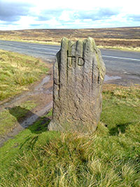
5. A further 200 yards leads us to the Hutton-Le-Hole to Castleton road where we find the large unworked boundary stone known as Margery Bradley 6. The stone marks the boundary of the 3 current parishes of Westerdale, Farndale East and Rosedale Westside. It’s inscription of “TD” stands for Thomas Duncombe who held the Honour of Helmsley in the early 18th century. His family was responsible for the building of the stately pile of Duncombe Park near Helmsley.
6. To return to the car park, simply follow the road north for ½ mile.
THE AREA is packed with fascinating heritage sites with the following within a 10-mile radius ;
Lion Inn at Blakey - ancient inn on old trade route, possibly monastic origin.
Lastingham - Norman crypt within St Marys Church.
Hutton-Le-Hole - Ryedale Folk Museum.
Kirkdale - St Gregorys Saxon Minster complete with 10th century sundial.
Rosedale - beautiful valley packed full of industrial archaeology including iron works and railways from 19th century.
The Milestone Society was established in 2001 to campaign for the conservation of milestones and other waymarkers, which are endangered by neglect, by vandalism and by casual destruction. You can find out more about our work plus details of the c 9000 milestones in the UK by visiting our website, www.MilestoneSociety.co.uk
While care has been taken to ensure the information above is accurate, the Milestone Society accepts no liability for any claim, loss, damage or injury (howsoever arising) incurred by those using the information provided. Please ensure that you wear suitable footwear and always carry a drink and a snack.
CLICK HERE to download a PDF to print out this walk
View Larger Map