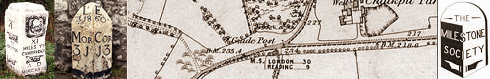
HIGHWAYS HERITAGE WALKS
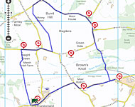
The Five Guide Stoops Walk, from Thurstonland
Walk Length: approximately 6km, allow around two hours. Alternatively, you may visit the stoops by road.
Grade: easy except for the optional medium walk though Clough Wood.
Start: : the Rose & Crown in Thurstonland, near Huddersfield/Holmfirth
Grid Reference: SE 1650 1042, OS Explorer 288. Postcode: HD4 6XU
Public transport: : bus 341 from Huddersfield or bus 911 from Honley.
Roadside parking in The Village; on wide verges beyond the church in Marsh Hall Lane.
Description
This circular trail visits five of the seven varied guide stoops in the Kirkburton Parish Council area, with some spectacular views over open countryside.
Route Instructions
1 Mid-18th century boundary stone
2 Grade II listed stoop, dated 1738
3 ‘miels’
4 ‘miles’
5 Second stoop
6 Third stoop
7 Fourth stoop

8 Fifth stoop
9 Ales from a micro brewery
After Roman times, roads developed to meet local needs. In 1555, an Act of Parliament made local parishes (or often townships in the North) responsible for their upkeep and boundary markers became important; you will see some on this walk.
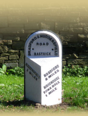
In 1697, County Justices were ordered to erect guideposts (stoops) on the moors and where highways crossed. These are often beautifully inscribed, with old spellings and lettering, with cuffed hands indicating directions and the distances in ‘long miles’, about a quarter longer than statute miles. Our walk visits five of these stoops.
Facing the Rose & Crown turn left (west) for 30m, then turn right onto a marked path between houses (Upperfold Barn). The path soon emerges onto an edge with spectacular views of the Holme Valley and the Pennines. Thurstonland church is on the right. The path crosses a stone stile, and continues in the same direction through fields. Notice also a round black air shaft of the Penistone railway line; the Thurstonland Tunnel runs directly underneath you.
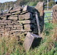
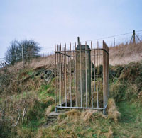
Go through a (probably open) gate, now keeping a wall on your right and at the end of this turn right over another stile onto a walled track. Immediately before this track turns left, cross another stile on the left and go past Heights Farm. Walk up the drive and turn onto Hall Ing Road. “Ing” is an Anglo Saxon term meaning ‘belonging to’. If you walk 100 yards to the left (west) along Hall Ing Road, you will see a mid-!8th century boundary stone hiding in the grass. 1 There is a similar boundary stone down Thurstonland Road.
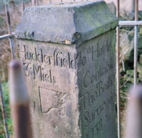
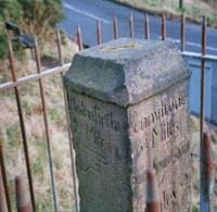
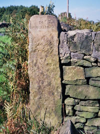
Turning eastwards along Hall Ing Road, you will reach the junction with Greenside Road and Thurstonland Road. On the left stands a Grade II listed stoop, dated 1738. 2 Cuffed hands point the directions to Holmfirth, Pennystone, Honley and Huddersfield; note the two spellings, ‘miles’ and ‘miels’ ! 3 & 4 The names of the Constable (John Hoyle) and Surveyor (Thomas Bothomley) are given. These were unpaid appointments, made annually, responsible for the upkeep of the local highways and organising compulsory labour for repairs and maintenance.
Continue along Greenside Rd and climb the stile (steps in the wall) opposite the lane to Blake House. The path crosses 8 fields and several stiles, towards Farnley Tyas church, which becomes visible from the third field. Tyas was the surname of an ancient local landowning family. There is a castellated reservoir building to the right; this supplies Storthes Hall Student Village, formerly West Riding Mental Hospital. After the 8 fields you reach a road, Moor Lane. Turn right onto this, and then right onto Farnley Road at the next junction, by a small factory. Continue along this road - there is a pavement. Just before Moor House (on the left) there is a mid-19th century triangular boundary stone marking the boundary between Farnley Tyas and Thurstonland townships.
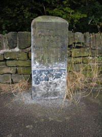
Our second stoop stands on the wooded corner of Storthes Hall Lane, showing the surveyor’s name, John Bottomley, and a date, 1861. 5
Continue along the road to find the third stoop, a simple stone incorporated into the wall at the top of Wood Lane, on the left hand side corner , “To Thunderbridge”. 6
Continue along the road, now Greenside Road, to Wood End house. By the drive, at a bus stop, the road curves right. Enter the house drive on the left, and immediately turn right down a field. [NB: Although the woodland track is scenic, it is quite steep and can be muddy, so if you prefer you can stay on Greenside Road to Brown’s Knoll Road and take this to stoop five.] At the bottom of the field you enter Clough Wood, and follow the footpath down the bank, over a footbridge at Clough Dike, and up a field. Pass through a sprung wooden gate stile and up the hill, entering Brown’s Knoll Wood. Follow the path down to another footbridge, over Town Moor Dike, and up to a stile at the railway line; cross carefully and climb the stepped stile at the far side. Follow the path uphill across the fields, bearing right onto a farm track to Stocksmoor Road.
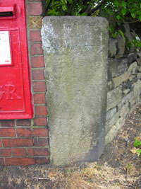
Walk 100 paces to the left along Stocksmoor Road to see the fourth stoop, at the junction with Cross Lane. This has hands pointing to Shepley and (now hidden by the letterbox) to Thunderbridge. 7
Retrace your steps and follow Stocksmoor Road west to the fifth stoop, which stands alongside the junction with Ing Head Lane and Brown’s Knoll Road. Note that Shepley is shown in either direction. 8
Now follow Brown’s Knoll Road north-west, shortly turning off left into Town Moor, returning past the war memorial through The Village to the Rose & Crown. This describes itself as “A friendly and cosy, rustic pub, with a great atmosphere and a good mix of real ales & real people”, the telephone number is 01484 660790. 9
We hope you have enjoyed this historical stroll, compiled by the West Yorkshire Group of the Milestone Society. The Society was established in 2001 to campaign for the conservation of milestones and other waymarkers, which are endangered by neglect, by vandalism and by casual destruction. You can find out more about our work plus details of the c 9000 milestones in the UK by visiting our website, www.MilestoneSociety.co.uk
While care has been taken to ensure the information above is accurate, the Milestone Society accepts no liability for any claim, loss, damage or injury (howsoever arising) incurred by those using the information provided. Please ensure that you wear suitable footwear and always carry a drink and a snack.
CLICK HERE to download a PDF to print out this walk