HIGHWAYS HERITAGE WALKS
By river and towpath, along the Rivers Croal and Irwell, and the Manchester Bolton & Bury Canal
Walk Length: approximately 5 ½ miles or 2 ½ miles**
Grade: mostly easy on towpath and tracks; may be muddy. Not suitable for mobility-impaired.
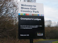
Start: Moses Gate Country Park, Hall Lane, Farnworth, Bolton, BL4 7QN (free car parking).
Grid Reference: 3 degrees 33' 25" N , 2 degrees 23' 22" W; SD 742 991 Postcode: BL4 7QN
Public transport: Bus: 524 (Bolton to Bury via Radcliffe).
Railway Station: Moses Gate (Manchester to Bolton).
Description
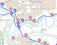
This walk follows the Rivers Croal and Irwell and the Manchester Bolton & Bury Canal through attractive countryside that was once a thriving industrial area. We see the surviving remains of transport from these busy days, including a number of canal milestones, a flight of six locks, an iconic steam crane, two impressive packhorse bridges and an aqueduct.
Route Instructions
1. Welcome to the Country Park.
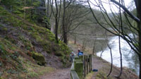
2. Rugged 'Red Rocks'.
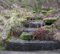
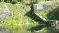
3. Red Rocks outflow.
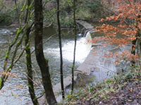
4. Weir.
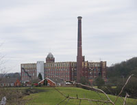
5a. Kearsley Mill.
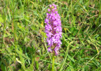
5b. Rare orchid .
6. Bottom Lock Entrance.
7. Staircase locks, Prestolee.
8. Packhorse bridge, sewer and viaduct.
9. Prestolee Bridge, No. 13.
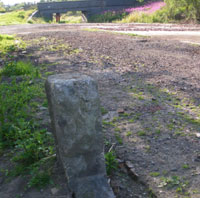
10a. Towpath and milestone.
10b. Milestone 7 1/2 miles.
11a. Sandstone slab fence.
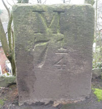
11b. Milestone 7 1/4 mls.
12a. Ringley Lock.
12b. Milestone 7 mls.
13a. Packhorse Bridge, Ringley.
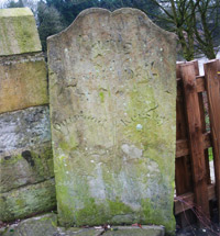
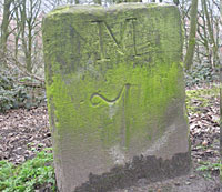
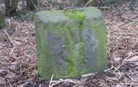
13b. Old parish boundary marker
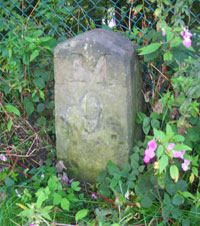
14. Milestone 9 mls.
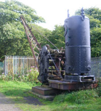
15. The Steam Crane.
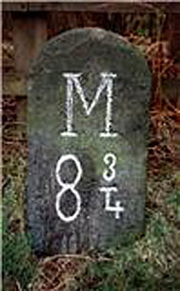
16. Milestone 8 3/4 mls.
17. Milestone in privet hedge.
18. The Breach.
19. Milestone 8 mls.
20. Nob End Bridge's bollards.
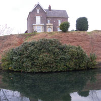
21. Wellfield House.
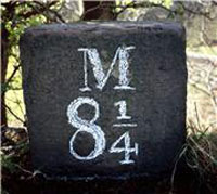
22. MS 8 1/4 mls.
23. Double stop-board slots.
24. Wildfowl haven.
24a. Row of swans on Wildfowl haven.
25. Milestone 8 1/2 mls.
26. Railway Boundary Marker.
27. Milestone 8 3/4 mls.
28. The remains of the canal viaduct.
29. Crossing the River Croal.
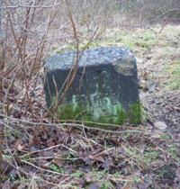
30. County Boundary Marker.
[ ** For a circular walk, approx 2½ miles, follow the instructions over the packhorse bridge to Prestolee Bridge, then turn leftwards back along the towpath.
Cross the Irwell, climb up to the top of the Prestolee flight of locks and turn right along the towpath for 250 yards towards Bury to view the breach,
then retrace your steps to rejoin the walk at Nob End, heading towards Bolton.
** For a linear walk, approx 2 ½ miles, follow the instructions to Ringley and catch bus 512/513 back to Bolton ]
1 Head towards the Rock Hall information centre, keeping by the river-bank. The walk starts from the Information Board by the weir. Follow the main path past the toilets along the River Croal. This grassy area was the site of the Farnworth Paper Mill, dating from 1674, owned by the Crompton family who built Rock Hall in 1807; the mill later became a bleachery. The path heads away from the river towards a red footbridge.
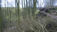
Cross the red bridge and turn right along the path, shortly climbing a flight of wooden steps and turning right through woodland following the river. After about 400 yards from the steps, continue to follow the river as the path forks to the right before dropping downwards; after rounding a bend under the ‘Red Rocks’ 2, a rugged outcrop, you can see the stones of a let-off (drain) 3 from the Bolton branch of the canal that is running along the top of the high bank on your left.
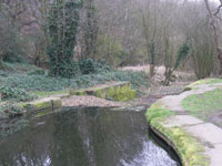
The river cascades over a weir. Oakes Bridge formerly stood on this weir, carrying a tram-road from the Croal Brick and Tile works on the opposite bank; it was demolished in 1987. Climbing up the path, there is a birds-eye view of the weir 4 from a seat just before a kissing gate; go though this gate. You will come to an open space with the imposing Kearsley Mill complex 5a & 5b in the distance; follow the centre path towards the mill. This area was the site of the Rawson’s Vitriol Works, founded in 1792 to make chemicals for bleaching and printing, later for washing soda. The works closed in 1883 and were levelled but the large quantities of alkaline waste that had been tipped have given the area an unusual flora, including a variety of orchids. Pass to the left of a large tree, crossing the remains of a watercourse that fed a dry-dock, to a path at right angles, the Croal Irwell Valley walk, and turn left, following the path through a metal kissing gate. Turn right along the fence and walk to the edge of the canal basin below Nob End.
The Manchester Bolton and Bury Canal was opened in 1797. It runs from Salford up the Irwell valley, crossing the River Irwell twice to reach Nob End. Here it climbs the spectacular Prestolee Locks and at its summit splits into two arms, one leading west to Bolton and one leading east to Bury. The canal was built to serve numerous collieries and to transport heavy materials; passenger (‘fly’) boats covered the length from Bolton to Manchester in three hours, while transport by road was slower. The canal was finally closed in 1961. For detailed information, see www.mbbcs.org.uk
From the edge of the canal basin, look left; under the footbridge you can see the branch that led to the chemical works and a dry dock, whose rectangular brick walls are obscured in the undergrowth. Cross the footbridge and climb upwards to marvel at the double staircase of locks which raised the canal 66 feet (20m) over 200 yards (180m) to Nob End. 6 The six Prestolee Locks were arranged in two flights of three, with a passing basin between. 7 They were partly demolished and infilled in the 1950s.
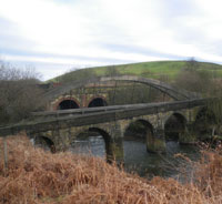
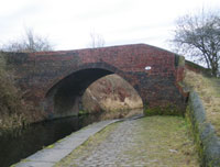
You will see the locks from above later in our walk, so retrace your steps back over the footbridge to the fence and walk left along this towards the River Irwell, on its way to its confluence with the Croal. The path leads over the impressive packhorse bridge, on the ancient route from Manchester to Bolton. Goods were transported on horseback through medieval times; highways were unsuited to wheeled vehicles. An Act of 1555 made the inhabitants of the parishes and townships responsible for the upkeep of the highways passing through them, levying several days each year of compulsory statute labour or payment instead.
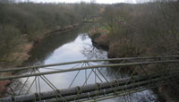
If you would like a good view of the bridge, walk a short distance down the footpath though the fence-gate just before the bridge, alongside the Irwell. 8 Packhorse bridges had low parapets to enable the bulky panniers to pass; as with many others, the parapets have been raised on this bridge which was rebuilt in 1805. A 20th century stone names it as C C (County Council) Prestolee Bridge. The adjacent concrete box-section bridge contains a sewer; this partly obscures the graceful arches of the aqueduct which carries the Salford branch of the canal over the Irwell.
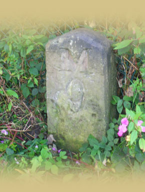
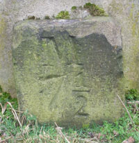
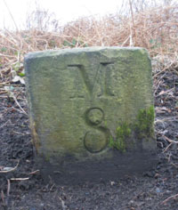
Cross the packhorse bridge, walk 50 yards up the track and turn sharp left up a narrow footpath to Prestolee Bridge, number 13, over the canal - it is also known as Seddon’s Fold or Silver Hill Bridge. 9 This is an original brick arch built in the 1790s; it featured in the 1970 James Mason film “Spring and Port Wine” about the life of a family in Bolton, (http://en.wikipedia.org/wiki/Spring_and_Port_Wine). Canal milestone with the legend “M 7¾” is thought to lie in the canal near this bridge.
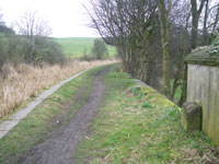
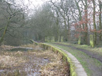
Turn left and descend to the towpath, then turn right under Prestolee Bridge and continue on the towpath towards Salford. Continue along the towpath for three-quarters of a mile; sections of the canal are blocked by vegetation. Passing under bridge no.11, you will find milestone 7½ at the end of a wall. 10 The spire of Prestolee church can be seen on your right along this quiet pleasant stretch of towpath. Milestone 7¼ is found beyond several tall thin sandstone fencing slabs, 11 high above the River Irwell in the valley below. Carrying charges were levied at quarter-mile intervals on the canal, hence the quarter-mile intervals between milestones.
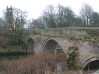
The canal becomes dry at Ringley Lock, 12 but follow the path, passing milestone 7, 13 to the A667 Kearsley Road, by Ringley Bridge over the River Irwell. The bridge replaced a ford; in medieval times, it was one of the few river crossing points between Bolton and Manchester. Irwell eels were renowned for their flavour, consuming a diet of fat, oil and grease released by the many fulling mills along the banks.
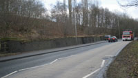
Because travel by road was slow and difficult and better trade routes were needed, Turnpike Trusts were established by Acts of Parliament from 1706 to 1840s. Groups of local worthies raised money to repair and later to extend the highway network. Users were charged tolls to pay for the work. The name ‘turnpike’ comes from the spiked barrier at the toll-bar. The Moses Gate and Ringley Road Turnpike Act was passed in 1830 and a new bypass road, the Kearsley Road, was built in the 1860s over the widened Ringley Bridge.
From 1767, mileposts were compulsory on all turnpikes, not only to inform travellers of direction or distances but to help coaches keep to schedule and for charging for changes of horses at the coaching inns. The distances were also used to calculate postal charges before the uniform postal rate was introduced in 1840.
Turn left, cross the road and make a pleasant diversion for c250 yards down Fold Road. Here you will find another spectacular packhorse bridge, 13a, opposite the clock tower; on the nearest side is a set of stocks and on the far side is an old parish boundary marker. 13b The bridge replaced a ford; in medieval times, Ringley was one of the few river crossing points between Bolton and Manchester. Later, Irwell eels were renowned for their flavour, consuming a diet of fat, oil and grease released by the many fulling mills along the banks. There are also pubs for refreshments at this half-way stage of the walk. "The Horseshoe" was a scheduled stop for all Manchester-bound packet-boats on the canal, which used to run at the side of the building. Here parcels were left for local delivery and the landlord served ale to thirsty passengers.
Return to the Kearsley Road; buses 512 and 513 stop here if you wish to return to Bolton.
Turn right and walk up Kearsley Road, crossing Prestolee Road, and turn left onto the farm track past Shore Top Farm. Beyond the farm buildings, look across the fields to your right to a metal bridge over the River Irwell. There is an indistinct footpath to the bridge from the gate across the track. Follow this. If you miss it, there is a gap in the fencing on the right-hand side (opposite a stile) just before the track turns left. Head for the bridge, over several small bridges amongst some trees. Cross the bridge and turn left along Mount Sion Road towards the pulp works and take the footpath uphill to the right just before the houses. At the top, through an opening in the wall, turn left onto the towpath of the Bury branch of the canal.
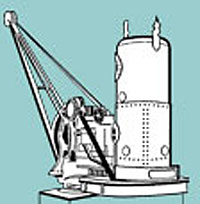
You will pass the Mount Sion pulp works below the canal; the canal widens at the site of a wharf that marked the end of a tramway which formerly led to several collieries around Stopes, half a mile to the north. Milestone 9 is encountered shortly afterwards, 14 followed by the Mount Sion steam crane, 15 which is used as the logo for the Manchester Bolton & Bury Canal Society. It was built in about 1884 by Thomas Smith & Sons of Rodley (Leeds) and it was used to lift containers of coal from boats and lower them into the yard of what was then a bleach works below.
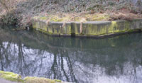
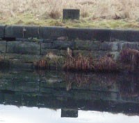
After the crane, pass milestone 8¾ 16 to reach Ladyshore Bridge, No. 15, (an 1894 blue brick replacement of an earlier bridge), which provided access to Lever Bank Bleach Works in the bend of the river below. Under the bridge you can see stop grooves, with the boards in place. This arrangement allows sections of the canal to be isolated separately and drained for maintenance work.
Beyond the bridge is the site of the Ladyshore Colliery on the opposite side of the canal. Ladyshore was originally opened in the 1830’s, and became (in)famous for being the last pit in Lancashire still to use candles for illumination and ponies for underground transport. In the 1890s, it had 3 shafts, the deepest being 360 yards (330 metres). However, by the start of the Second World War, it was the only colliery remaining on the whole length of the canal, with most of its production being transported by canal. It had its own fleet of boats and as late as 1941 it sent over 50,000 tons of coal by boat to Radcliffe and Bury. It closed in 1949.
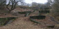
breach in the canal that we will encounter shortly; it enables water to continue to feed the canal below Prestolee Locks. The dry canal bed sweeps to the right and in 200 yards you will see milestone 8 1/4 17. Pick your way carefully under the Bailey Bridge(an 1891 replacement of an earlier bridge) with its bright red stanchions and continue along the towpath to where the canal was breached on 6th July 1936. Failure of the embankment carried away 20 yards of towpath and canal wall, depositing tons of debris in the valley below, damming the river and emptying the canal. 18
Because there was little traffic, the breach was not repaired and there have been further slips since. Follow the path into the canal bed round this spectacular disaster site and then rejoin the towpath. In the breach you can see the high quality massive construction of the canal wall. Railway lines can be seen on the left which were used to strength the embankment in 1881. Along the centre of the canal bed is the water pipe that was installed after the breach so that the canal could continue to supply factories further down the valley with water.
On regaining the towpath, there is a short length of dry canal leading to the Nob End junction. Here the canal is supported high above the valley by massive brick retaining walls, mostly constructed in the 1890’s.This section of the canal has been cleared of vegetation by the Canal Society and the Waterway Recovery Group, most recently in December 2010. Just before the Nob End junction, you will see milestone 8 behind a chainlink fence. 19
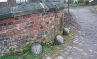
As you reach Nob End, pause and look down the Prestolee staircase of locks, imagining the bustle of the bargees in its heyday. Continue across the top of the locks to the Nob Bridge which is over the start of the Bolton branch; the former Nob Inn stands above the bridge, which has stone bollards. 20 Continue forwards along the cobbled towpath towards Bolton; on your left are the canal workshops, now derelict, two former canal company cottages, and the larger house of the canal manager. Across the canal, set high, is the impressive Wellfield House, with its precision engineering brickwork and tall windows. 21 Around the corner extensive views towards Bolton and Winter Hill open up.
Continue along the cobbled towpath; just beyond the 8¼ milestone, 22 note the double grooves for stop planks at a narrowing of the canal 23 and the channel on your left leading down to the river at the Red Rocks; the double grooves allowed the canal to drained from either side.
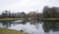
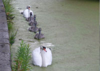
The canal soon widens to form a basin known as Top o’ th’ Lodge, from which a tramway once ran to a colliery; the basin is now a haven for swans and other water birds. 24 As the towpath leaves this stretch, you can see more grooves for stop planks (a single set this time), by the 8½ milestone. 25
The canal embankment along this stretch is supported by a wall of blue bricks; the top of the wall can be made out through the vegetation although the wall itself can only be seen from the woodland track below. Continue along the towpath until a busy road comes into view. The canal widens into another large basin called the Salt Harbour, because barges brought cargoes of salt from Nantwich for the local chemical works. Pausing just before the basin, by a faint number 2 painted on the edging stones for anglers, you can see a boundary stone on the opposite bank. 26 This was a Lancashire and Yorkshire Railway Company marker – a railway from Manchester to Bolton was opened by the canal company in 1838 which caused canal traffic to decline. The canal and railway were later taken over by the L&YR.
Just before you leave the basin, on your left, in a hedge behind a fence, you will see the 8¾ milestone. 27 The canal is dry beyond this point; our walk continues straight across the car park area. Do not go through the kissing gate into Canal Wood but climb the stile to the right of this. The path then drops steeply down through a kissing gate by the pedestrian traffic lights on Hall Lane. The canal itself crossed the road by an aqueduct – all that remains today is a short length of the blue brick wall of the abutment on the far side of the road. 28
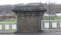
We turn left down the road and cross the Croal 29 over the Farnworth Bridge with its substantial stone pillars. One is inscribed ‘CC Farnworth Bridge, Little Lever’ and another ‘County Borough Bolton, Great Lever, reconstructed 1990’. A third incorporates an old Bolton boundary marker. 30 Over the bridge, turn left back into the Country Park and return to your starting point.
We hope you have enjoyed this historical stroll, adapted by Milestone Society members from a walk by John Fletcher and Paul Hindle of the Manchester Bolton & Bury Canal Society; the Society aims to restore the canal to join the national waterways network: see www.mbbcs.org.uk
The Milestone Society was established in 2001 to campaign for the conservation of milestones and other waymarkers, which are endangered by neglect, by vandalism and by casual destruction. You can find out more about our work plus details of the more than 9000 milestones in the UK by visiting our website, www.MilestoneSociety.co.uk
While care has been taken to ensure the information above is accurate, the Milestone Society accepts no liability for any claim, loss, damage or injury (howsoever arising) incurred by those using the information provided. Please ensure that you wear suitable footwear and always carry a waterproof, a drink and a snack.
CLICK HERE to download a PDF to print out this walk