HIGHWAYS HERITAGE WALKS
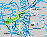
South Gloucestershire Stroll from Willsbridge
Walk Length: approximately 2 ½ miles OR 3 ½ miles OR 5 ½ miles.
Grade: mostly easy on roadside and tracks; may be muddy. Flight of steps on shortest option, stiles on longer walks.
Start: Avon Valley Railway, Bitton Station Centre, A431, free parking; excellent café.
Location: www.avonvalleyrailway.org/find/roadmap.html
Start Grid Reference: 51 deg 25’ 28” N 2 deg 27’ 34” W; ST 669 703 Postcode: BS30 6HD
Public transport: Buses from Bristol Parkway, Central Bristol and Bath: www.firstgroup.com
Description
This walk follows in the steps of the Romans and the later Turnpikes of the Bristol Trust, taking in a number of milestones, waymarkers and boundary markers and a superb toll-house; on the longer walks, there are extensive views over the surrounding countryside. There are several refreshment stops and toilets along the way.
Route Instructions
1. Bath Guidestones.
2. Toll-house.
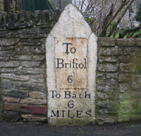
3. Milestone, Bath 7 mls.
4. Oldland buildings.
5. Guidestones to Bridgeyate.
6. To Warmley.
7. Down the cycle-path.
8. Footpath signs and stile.
9. Panoramic views.
10. Clay Lane end.
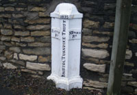
11. Milestone, Bristol Trust, 6 mls.

12. Bitton snowdrops - Wikipedia.
12b. Modern plaque.
13. Upton Cheyney guide stone.
14. Turnpike Trust Parish Boundary Marker.
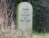
15. Millennium Parish Boundary Marker.
16. Milestone, Bristol 7 mls.
17. Path above River Avon.

18. Modern Waymarker.

19. Avon Valley Railway.
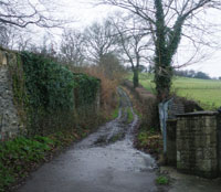
From the Bitton Railway Centre carpark, walk down to the main road, the A431 Bath Road and turn left. After 200 yds, cross the slip road (signed to Warmley) and continue to the corner of the grass triangle. Here you will see a splendid waymarker or guide post 1 . Walk to your right towards Warmley, up Cherry Garden Road, the A4175; a Roman road runs parallel alongside this on the right.
There was no national road system after the Romans left in the 5th Century until the 18th Century. Travel was on tracks and highways maintained from 1557 by local parishes; everyone was obliged to provide a number of days labour each year or to make a payment instead. Because the state of the highways made travel slow and difficult and better trade routes were needed, Turnpike Trusts were established by Acts of Parliament from 1706 to 1840s. Groups of local worthies raised money to repair and later to extend the highway network. Users were charged tolls to pay for the work. The name ‘turnpike’ comes from the spiked barrier at the toll-bar. The A4175 road through Oldland was part of the Bristol Turnpike Trust’s remit; this trust was set up in 1727 and its Surveyor in the early 1800s was John Loudon McAdam, whose descendants were of Tarmac fame.
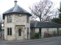
As you toil up the hill, imagine the Roman legions in full armour or the heavily laden packhorses cursing the gradient too! At the top of the hill, you will see a superb example of a well-restored toll-house. 2 This was probably not a welcome site for travellers in the 1700s and 1800s because tolls were resented by most road users.
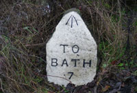
After half a mile, you will see a milestone on the right-hand side, just before St Anne’s Drive. 3. From 1767, mileposts were compulsory on all turnpikes, not only to inform travellers of direction or distances but to help coaches keep to schedule and for charging for changes of horses at the coaching inns. The distances were also used to calculate postal charges before the uniform postal rate was introduced in 1840. This milestone is an early example and also has a benchmark, the Ordnance Survey datum height above sea-level.
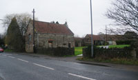
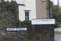
Passing some attractive old buildings, 4 on the outskirts of Oldland Common, continue to the Cherry Tree pub, at the corner of West Street. Look across the road to see two waymarkers, one pointing to Walmley, the other to Bridgeyate. 5, 6
Oldland Common, mentioned in the Domesday Book, was the birthplace of the famous astronomer Sir Bernard Lovell; the eponymous secondary school was attended by England cricketer Marcus Trescothick. The village was involved in the coal mining industry and had its own pit on Cowhorn Hill during the 1800s.
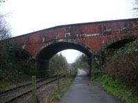
** For the shorter walk, follow West Street over the railway bridge and take the path immediately on the righthand side down to the cycle way, 7 descending a short flight of steps and turning right under the bridge, along the railway track that leads you back to the starting point at Bitton station (approx one mile). You might like to make a detour through Willsbridge Mill nature reserve with its intriguing modern waymarkers: www.avonwildlifetrust.org.uk If so, while walking back to the start point along the A431, look out for the waymarker on the wall at the junction with the A4175 Keynsham road.**
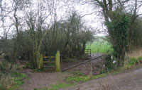
For the longer walks, cross the High Street and retrace your steps down Barry Road to the footpath on your left opposite Chequers Close. Go through the metal kissing gate and follow the ditch and hedge to the corner of the field and footpath signs. 8 Take the right-hand path, climbing the stile and after a few yards enter a large field. Aim south-east across this, towards Lower Cullyhall Farm. Climb a stile and skirt the farm buildings on your left.
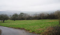
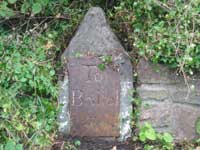
Climb another stile, cross the track that leads to the caravan site and continue over another stile, up the footpath with the hedge on your left, to the top of the hill. Pause to admire the extensive views over the rolling countryside. 9 Climb the stile and walk down the tarmac of Clay Lane. The tarmac eventually becomes a muddy track, impassable by saloon cars. 10 At the end of Clay Lane, turn left along the A431 Bath Road and walk a few yards into Bitton, looking along the wall on your left. You will see a large 1700s milestone set into the wall just before Tayman Ridge. 11
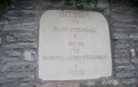
In the 1860s, Canon Ellacombe promoted the distribution of the robust, large, early-flowering snowdrop Galanthus nivalis 'Atkinsii' 12 "that grew at the south wall in his garden in Bitton." Continue over the River Boyd along the Bath Road; opposite Church Lane, you will see a modern plaque set in the wall 12b
Continue over the River Boyd along the Bath Road; after half a mile, you will find another guide stone, again with an Ordnance Survey benchmark, but not showing a distance, at the junction with Upton Cheney road. 13. Continue for another half mile to the village of Swineford, which developed near the point where a small tributary of the Avon crosses the old Roman road from Bath to Bristol. Legend has it that Swineford is where Prince Bladud herded his pigs across the river and the mud provided a cure for his leprosy and that of his pigs.
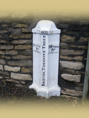
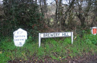
Pass the Swan Inn www.bathales.com/pubs/swan-swineford.html and notice the small Victorian postbox set into a wall. Opposite Somerset House in the village you will find a Bristol Turnpike Trust Boundary Marker dated 1823, 14 with the names of the bordering parishes, Bitton and NStoke displayed. Continue along the road 150 yards and you will see its millennium counterpart on the right-hand side, a Bitton Parish stone. 15 Shortly beyond it, now in Somerset, on the left-hand side is another early milestone of the Bristol Trust, beside the wall of PlantCare. The legend shows the old letter s written like an f. 16
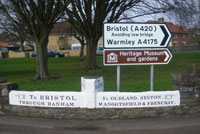
You have now walked approximately 3 ½ miles. If you wish to return direct to our Bitton Station starting point, you can catch a bus opposite the Swan Inn; the 332/632 and 619 go to Bristol Centre or Parkway, or on the same side of the road as the Swan for Bath. Check the times on www.firstgroup.com
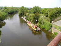
If you wish to continue walking, take the footpath opposite the Swan and slightly left, signed Keynsham, and follow it to the towpath of the River Avon, around lush level fields fringed with willows. When you reach the viaduct/embankment, 17 turn right up the cycle path www.paulspages.co.uk/bbcycle/bbcycleclassic.shtml along the old railway line that leads back to the starting point at Bitton station, total 5 ½ miles. You will find a railway milemarker hidden amongst the shrubs and a modern waymarker close to the station.18
The railway volunteers organise a number of days under steam or vintage diesel – see their website, www.avonvalleyrailway.org for details.19
We do hope you have enjoyed this historical stroll, compiled by members of the Milestone Society. The Society was established in 2001 to campaign for the conservation of milestones and other waymarkers, which are endangered by neglect, by vandalism and by casual destruction.
You can find out more about our work plus details of the c 9000 milestones in the UK by visiting our website, www.MilestoneSociety.co.uk
While care has been taken to ensure the information above is accurate, the Milestone Society accepts no liability for any claim, loss, damage or injury (howsoever arising) incurred by those using the information provided. Please ensure that you wear suitable footwear and always carry a drink and a snack.
CLICK HERE to download a PDF to print out this walk