HIGHWAYS HERITAGE WALKS
Meet Some Milestones on the Kirklees-Calderdale border
Walk Length: approximately 3.5 miles.
Grade: easy, on narrow woodland tracks and roads. Not suitable for wheelchairs/pushchairs.
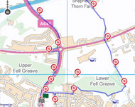
Start: The ASDA roundabout on the A641, Bradford Road, Huddersfield.
Grid Reference: SE 148 192 Postcode: HD2 2LQ
Public transport: Bus 363 from Huddersfield Bus Station or Bradford Interchange.
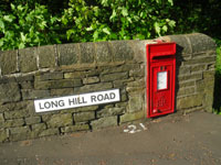
Roadside parking in Long Hill Road.
Description
The route crosses Lower Fell Greave Woods and then follows the Old Lane, a packhorse track, uphill to meet Shepherds Thorn Lane across the Dewsbury to Elland turnpike, and descends into Calderdale. We turn back up the Huddersfield-Low Moor- Bradford turnpike, passing some milestones, to the starting point.
Route Instructions
1 Long Hill
2 & 3 New waymarkers
4 Start of the walk
5 & 6 New House Hall & close up of
mullion window
7 Bradley Gate
8 Layering
9 Cross the M62
10 Scout Camp
11 Cellars remains
12 Remains of a raised causeway
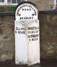
13 ‘Brayshaw & Booth’ milestone
14 Victorian cab fare stages
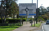
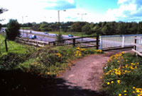
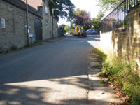
15 Roundabout at Bradley Bar
16 Brayshaw & Booth milestone
17 Bluebells
18 To & From stone
Walk up the Bradford Road ( the Huddersfield – Low Moor and Wibsey turnpike of 1826, extended Bradford in 1840), and turn right into Long Hill Road 1 , a new housing estate.
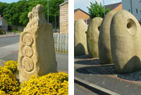
If you detour a short distance up Hopkinsons Road on your right, you will see some new waymarkers 2 & 3 , commissioned in 2004, when the estate was rebuilt.
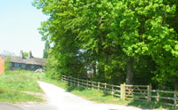
Continue up Long Hill Road and turn left into Fell Greave Road then pick up the Kirklees way to the right; into Lower Fell Greave Woods 4 . These woods belonged to Fountains Abbey in the 13th Century.
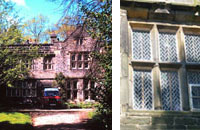
Follow the path to the right, towards the perimeter of the wood; a short detour between some stone walls takes you to haunted 5 & 6 New House Hall. In the 17th century, a lovely young daughter of Sir Joshua Brook was courted by a young man of whom her father disapproved. The beau sent messages tied to his dog’s collar, but one night the father discovered the dog and chopped its head off with his sword. The dog ran back howling through the woods! The young man was discouraged and left the district; the daughter pined away. She and the dog can be seen in the woods on dark nights…
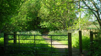
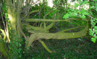
Return to the woodland path and continue along the brook, carefully because it can be slippery under foot, over the stepping-stones and bridge then up the bank to 7 Bradley Gate. This was the boundary between Bradley Manor and the Manor of Huddersfield. Turn left up Old Lane, which dates from the 16th Century. This was the main packhorse route between Huddersfield and Bradford until the Bradford Road was completed in 1840. As you walk up Old Lane, note the ancient 8 “layering” in the hedgerow on the right and the variety of trees in the woodlands.
If the weather is clear, there are excellent views towards Dalton and across Huddersfield.
Cross the A6107, 9 ( the 1759 Dewsbury to Elland Turnpike), passing the site of a tollhouse demolished in the 1940s. Because road travel was slow and difficult and better trade routes were needed, Turnpike Trusts were set up by Acts of Parliament from 1706 to 1840s, to repair and later to extend the highway network. Users were charged tolls to pay for this work. The name ‘turnpike’ comes from the spiked barrier at the Toll Bar. From 1767, mileposts were compulsory on all turnpikes, not only to inform travellers of direction and distances, but to help coaches keep to schedule and for charging for changes of horses at the coaching inns.
Now follow the packhorse track down Shepherd’s Thorn Lane (part of the Kirklees Way) past the golf course. The track bears left beside some holly bushes and through more woodland, with layered hedging visible on the left side. Cross the M62 (late 20th Century!) by footbridge. Continue on the track which becomes a tarmac lane as you pass the 10 Scout Camp.
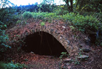
The arches on the next hill are cellars, 11 all that remain of Throstle’s Nest village. Note how the dry stone walling on your right mounts the slope.
Next, 12 look for some slabs in the ground by the wall on your right; these are the remains of a raised causeway (pavement) where horses or travellers could walk clear of the muddy ruts left by carts, the ‘holloway’. Better preserved causeway stones are found beside the last bungalow.
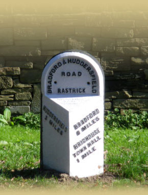
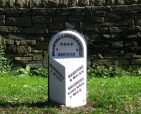
At the end of Shepherd’s Thorn Lane, turn left onto the Bradford Road. The packhorse route itself continues down Toothill Lane, to the old bridge crossing the Calder at Brighouse. Walk up the Bradford Road back towards Huddersfield and at the start of the wide grass verge you will meet a cast iron 13 ‘Brayshaw & Booth’ milestone, which gives directions to Brighouse Town Hall, Huddersfield and Bradford. These milestones were erected by the new West Riding County Council in 1893, replacing the original turnpike milestones.
The verge along the roadside becomes narrow: if you prefer, you can cross the dual carriageway at the milestone and walk along the footpath on the far side, then cross back when you are over the motorway bridge.
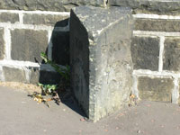
Continue along the side of the dual carriageway; at the top of the hill you will find a small triangular stone 14 ‘To & From’ milepost, saying “To Huddersfield 2.5 miles” on one side and “From Huddersfield 2.5 miles” on the other. These are Victorian cab fare stages, at half-mile intervals on all the radial routes within the town boundary. 15 Continue to the roundabout by Villa Farm, Bradley Bar. The toll house was located on the plot of woodland on the right hand side. Cross Bradley Road at the refuge and walk a few yards left along the 1759 Dewsbury to Elland turnpike; you will see another 16 Brayshaw & Booth milestone. This one is the right height above the ground; the road surface has risen to engulf the previous milestones.
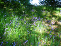
Walk back to the Bradford Road, turn left down the hill and if it is Spring, 17 enjoy the bluebells carpeting the woods on either side. Should you wish to extend your walk, follow the Kirklees Way through Upper Fell Greave Woods and across Huddersfield Golf Course, passing Fixby Hall.
Continue on the Bradford Road to the starting point, 18 where you will see the next To & From stone; for refreshments, try the Asda café.
The Milestone Society, established in 2001, campaigns for conservation of milestones and waymarkers, which are endangered by neglect, by vandalism and by casual destruction.
You can find out more about our work plus details of the c9000 milestones in the UK by visiting our website, www.MilestoneSociety.co.uk
While care has been taken to ensure the information above is accurate, the Milestone Society accepts no liability for any claim, loss, damage or injury (howsoever arising) incurred by those using the information provided. Please ensure that you wear suitable footwear and always carry a drink and a snack.
CLICK HERE to download a PDF to print out this walk