HIGHWAYS HERITAGE WALKS
Explore the boundaries of Halliwell…
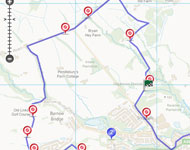
Walk Length: 7 miles, can be done in two separate sections.
Grade: The country walk section (4 miles) is over fields, stiles and along highways; the town walk section (3 miles) is on pavements and earth / stone tracks with some steps; not suitable for the mobility impaired.
Grid Reference: SD 69942 11878
Postcode: BL1 7NR
Public transport: Smithills Country Park is accessible by bus numbers 525, 526, and 27 from the Bolton Interchange adjacent to Bolton railway station Click here for details
Rail Station: Bolton
Parking: in the car parks of Smithills Country Park (no charge)
Description
This walk forms a ‘figure of eight’ around Smithills Hall. Explore some of the early routes and history of Halliwell, climb the hillside to marvel at the view from Scout Road, before returning past more milestones and an ancient cross. Pause at Smithills Hall and then discover some of the transport & industrial heritage of the old Halliwell township and anecdotes about its illustrious residents.
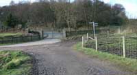
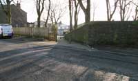
1 Coaching House Restaurant
2 Tippett House Gates
3 Boundary stone
4 “To Bolton 3 miles”
5 Enter golf course
6 Exit golf course
7 Across the fields to Whalley Avenue

8 Ancient cross
9 Bolton 3 miles
9a Chimney
9b Small bollards
9c Small bollards
10 Halliwell Hall

11a Carved head of a lady
11b Florence Nightingale
12 Cunliffe Brow track
13 Ivy Cottage
14 Three storey workers cottages
15 Arkwrights Alehouse
15a Caption?
16 Boundary Marker
17 Tollhouse
18 Astley Brook boundary marker
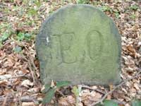
19 Eden's Orphanage marker
20 Bolton 2 miles milestone
Route Instructions
From the courtyard of the Coaching House Restaurant, 1 turn right. Turn right again then quickly take the path off to the left of a barred gate with the sign “Vehicular Rights”. Continue along this path as it curves right to reach the site of a disused garden centre with a high surrounding brick wall. Turn left to follow the path in front of the surrounding brick wall. Follow the path through a gate and then up to a T junction at the large gates 2 of Tippett House and turn right.
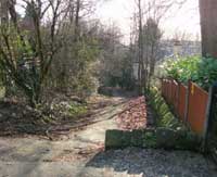
Follow the path down through another gate into Horrocks Wood and then up and round a bend to come to a fork junction by a picnic bench and large rock. Take the left hand path up the hill along the Boundary of Halliwell township to reach Horrocks Wood car park on Scout Road, a section of the Bolton to Nightingales turnpike extension 1805.
Because travel by road was still slow and difficult and better trade routes were needed, Turnpike Trusts were established by Acts of Parliament from 1706 to 1840s. Groups of local worthies raised money to repair and later to extend the highway network. Users were charged tolls to pay for the work. The name ‘turnpike’ comes from the spiked barrier at the toll-bar; we will see an example of a tollhouse on our walk and there is another at Doffcocker on the Chorley Old Road Turnpike of 1763.
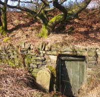
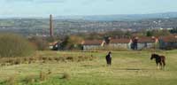
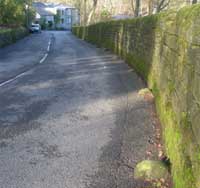
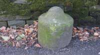
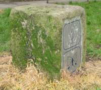
Admire the views across the North West, including Manchester, the Peak District, Fiddlers Ferry, Widnes power station cooling towers and beyond. Turn left out of the car park entrance, walk 350 yards along the turnpike and watch for a boundary stone on the right hand side, next to a wooden door leading into the bank under a mossy tree. 3 Legend: “Division Halliwell / Little Bolton”
Shortly on your left you will see Bryan Hey Farm, where ice creams (well worth sampling!) and hot drinks are available, although only at weekends during the winter months.
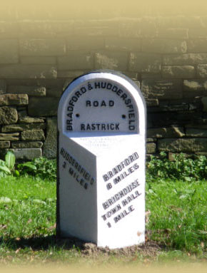
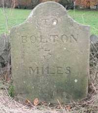
Continue along Scout Lane; there is a seat by the junction with Smithills Dean Road, if you would like a rest. Cross the junction and continue along the road, now called Colliers Row Road. After 250 yards, you will see another milestone set in the verge on the left, “To Bolton 3 miles”. 4
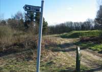
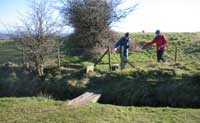
From 1767, mileposts were compulsory on all turnpikes, not only to inform travellers of direction or distances but to help coaches keep to schedule and for charging for changes of horses at the coaching inns. The distances were also used to calculate postal charges before the uniform postal rate was introduced in 1840. Walk another 350 yards west and opposite the old School House, you will see a sign to Barrow Bridge, pointing left down Long Shaw Ford Road. Walk down this road until you come to a bridge over the Dean Brook where the road turns to the left. Instead, bear right and take the left of the two sign-posted footpaths, marked Walkerfold Road 1½ km. Follow this footpath, a setted pack-horse track, up on to a golf course. When you reach a ‘Restricted By-Way’ sign on the left, 5 walk to the right-hand side of this and turn right after 80 yards. Bear right before the 7th tee, passing a clump of pine trees on your left. Heading due south, walk over the rough grass, to the left of the fairway. Pass to the right of the 17th tee, then cross the 18th fairway to a small footbridge and stile on the boundary, 6 leaving the golf course.
Cross the stile, turn left and immediately bear right to walk with the hedge on your right. At the end of the hedge, turn to leftwards bearing south east 7 across the fields to reach Whalley Avenue. Turn right along this road; the name changes to Hollin Hay. Follow this road to the junction with Montserrat Road. On the right hand corner stands the church of St James the Great. In the church grounds behind a tall hedge, raised proudly on a bank, you will see the cross 8 that was used as a bridge over the Doffcocker stream in Valletts Lane to desecrate it. The back was worn hollow by generations of clog-wearing wayfarers.
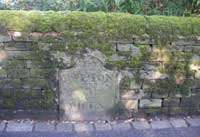
Turn back along Monserrat Road and continue along Lightbounds Road, a split-level carriageway. Turn right down Worston Avenue and at the end of the houses on the left hand side, take a footpath to the left of the gates and follow the path along the back of some houses with woods to the right. At the end, turn right down a walled lane. After 200 yards, watch for another milestone, 9 set into the wall on the left with the legend “Bolton 3 miles”.
Continue along the lane to enter Moss Bank Park, which includes gardens and a children’s playground www.bolton.org.uk/mossbank.html
It is easy to make your way back to Smithills Hall at this point although our walk continues along a path to the main Moss Bank Park car park.
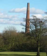
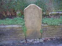
To return to Smithills Hall, turn back up the lane and turn right along a signed footpath. Follow this dropping down across a field to Barrow Bridge Road. Turn right along the road, noting the reservoir above the houses on your left! Turn sharp left just past a tall chimney 9a and continue down Smithills Croft Road. There are small bollards at the base of the walls, 9b, 9c, probably to keep wheeled traffic from damaging the wall. Where Smithills Croft Road turns sharp right, take the signed footpath to the left. Follow this to Limefield Road and turn right. At Abercorn Road, turn left to Smithills Dean Road. Turn right and 40 yards further, in the wall, you will see a milestone, Bolton 2, 20. which was defaced in WWll. The initials CDR at the foot belong to the resident who re-cut it in 1987. Turn back and continue up the road for 250 yards and turn right into the entrance of Smithills Hall, www.bolton.org.uk/smithillshall.html and en.wikipedia.org/wiki/Smithills_Hall You can enjoy refreshments in the Coaching House restaurant: www.smithills.co.uk
Our walk continues through the Moss Bank car park; cross the A58 Moss Bank Way at the traffic lights, into Captain’s Clough Road; we will meet the “Captain”, Roger Dewhurst, shortly. Take the first left into Church Road at a mini roundabout. This was an ancient highway, originally known as the Upper Causeway; once you reach Harper’s Lane, Church Road became the Lower Causeway.
After the Romans left, there was no systematic road construction. Goods were carried by packhorses though the Middle Ages and later, because the highways were not suitable for wheeled vehicles; usually a flagged stone causeway was the best surface, often with a sunken lane or holloway alongside, to permit passing. From 1555, the parishes and townships were made responsible for the maintenance of their roads. Individuals had to provide compulsory labour or a payment in lieu, the earliest form of ‘rates’ or council tax called the Composition – which was most unpopular. From 1697, the Justices were required to erect waymarkers where tracks crossed, to guide travellers.
Harpers Lane is a modern spelling for it commemorates the Harpur family. Harpurs Farm stood in the lane a little way further down but was demolished just after the Second World War. It was the old manor house of Halliwell dating back to at least the early 17th century. The Harpurs held land here from the mid-16th century, the eldest son of the family always being named John.
In the early 1600's John Harpur married the daughter of Robert Lever of Rivington. Their son studied theology at Cambridge. He was a great Puritan sympathiser and after obtaining the post of curate of Bolton became its vicar in 1644 during the Civil War. He died in 1657 and is buried in Deane Churchyard. His celebrated gravestone alone is well worth a visit to this tranquil place. One of his sons, Robert (obviously not the first son) also became the Vicar of Bolton.
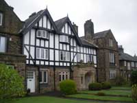
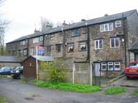
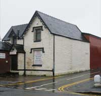
On the right of Church Road, you can see a rambling building, partly half-timbered, with an older middle section. 10 This was Halliwell Hall, built by Roger Dewhurst Senior, father of Captain Roger. The latter Roger Dewhurst was Treasurer of the Bolton to Nightingales turnpike of 1763 that ran along what is now called Chorley Old Road. He was also a civil engineer, magistrate, diarist, farmer, landlord, and not least a skilful artist. He attained the rank of captain, possibly of the militia although this is not certain.
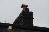
After another 100 yards, Inkerman Terrace on the left is a row of mid-19th century stone houses, named after the Battle of Inkerman in the Crimean War in 1854. 11a On the right-hand chimney stack is a carved head of a lady wearing spectacles, reputedly that of Florence Nightingale. 11b At the end of the gable on the adjacent building is an older carved stone with the head of Mr Punch on the west side and Judy smiling on the north side, although she is only visible from the rear alley, back Church Street N. Its date is said to be 1811.
On the right opposite Inkerman Terrace, turn down a footpath, the first part of an old track called Cunliffe Brow. 12 A gatehouse to Halliwell Hall was just a short way down on the right hand side. Continue into Burnside Road, turn left into Orwell Road and then right into Brentford Road. After 50 yards, continue straight on down a footpath, 13 which is the continuation of Cunliffe Brow. On the right hand side of the path is the now uninhabited Ivy Cottage that dates back to the 17th century. There are records that Roundhead troops were quartered there during the Civil War, and in more modern times tales of a ghostly military presence. Cunliffe Brow was one time known as the Captain’s Ride, being the route that Roger Dewhurst used to travel by horse between Halliwell Hall and his own private toll gate on the Bolton to Nightingale turnpike at the junction of Chorley Old Road and Ivy Road. At the bottom of Cunliffe Brow, turn right into Ivy Road; if you look straight down to Chorley Old Road, you will see Buildbase, part of the old site of the largest mill complex in England at the beginning of the 20th Century, Musgraves Atlas cotton mills, comprising 8 mills. The last mill chimney was demolished by Fred Dibnah. There are 2 remaining mill buildings, with the Northern Steam Engine Museum housed in one of the warehouses at the back (only in steam at bank holidays).
Walk 200 yards down Ivy Road, and turn left into Vallett’s Lane. This lane was called after an unfortunate Frenchman, ruined by the Ainsworths, bleachers of Halliwell and one time owners of Smithills Hall. Victor Vallett and his father Mathew were brought over from France by the Ainsworths to develop a chemical bleaching process for cotton instead of the traditional laying out process to bleach in the sun that was lengthy and weather prone. During the late 1700’s Mathew Vallett became involved with hot air ballooning using his own apparatus and gas supplied from a factory just outside Paris that he owned with a partner Leonard Alban. He was also experimenting with chemical bleaching to speed up the bleaching of cotton, which is how the Valetts came to the attention of the Ainsworths. Unfortunately, their work did not come up to the expectations and the Ainsworths had Victor Vallett declared bankrupt.
Walk along the lane and after the lane bears left there is a row of three storey workers cottages on the right. The Ainsworths built the cottages in the late 1700’s as a chemical works for the Valletts and they were known locally as ‘Chemical Hall’. 14
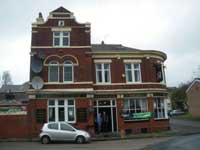
Just before the lane bends right at the Arkwrights Alehouse, 15 there used to be a bridge over the Doffcocker (‘dark water’) brook, which is now culverted. This bridge was made from the ancient stone cross, probably Celtic or Anglo Saxon, which was defiled when ‘Popists’ were out of favour that we saw at St James’ church earlier in our walk. 8
Beyond the Alehouse, the lane curves uphill, skirted by a high stone wall. Harry Waring had a museum in his house here; one curiosity was a piece of Noah’s Ark, commemorated in verse:
He’s also got a bit of wood
That came from Noah’s Ark
When it grazed the top of Rivington
As it sailed o’er in the dark.
As the lane levels out, turn right at the junction with Elgin Street. Pass the mosque and follow the continuation, Harold Street, bearing to the right of St Joseph’s redbrick Roman Catholic church into Back Apple Terrace. Continue straight ahead along a public footpath which comes out into Boundary Street. Some 30 yards along the right hand side of the street on a grass verge is a small boundary stone 16 with the legend 8 on the top. Turn left at the end of the street into Portland Street, then turn sharp right into Burke Street and then left into Hargreaves Street.
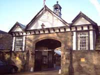
At the junction with Halliwell Road, you will find a Toll house on the right hand corner. 17 While on busy turnpikes the right to collect tolls was auctioned, on quieter routes the toll keepers were employed by the Trustees. The plots on which toll houses stood were the only land actually owned by the trustees; they leased the roadways.
Turn left along Halliwell Road, part of the Bolton to Nightingales turnpike extension 1805. The houses are attractively presented, part of a conservation area. After 50 yards, turn right Into Weymouth Street. Continue along the street for 160 yards to a where the street turns left into Leybourne Street and take the pedestrian footpath almost straight ahead to the left of Wheedale Close. At the end of the footpath, turn right into Crumpsall Street and then almost immediately turn left into Chapelfield Street. At the end of the street, go straight ahead over a grass area onto a sign-posted public footpath. Just at the start of the public footpath to the right of a tree, 18 there is a boundary marker lying on its side with the legend 2.
Continue along the footpath with Astley Brook on the right. Cross over a road and continue along the footpath through a new housing development. On the far bank of the brook just before a footbridge over the brook, there is a group of 3 stones each with the legend EO. 19 This is the boundary of Edens’ Orphanage, set up in the late 1800s to cater for poor children, although the regime was harsh. Continue along the footpath into Temple Road and take this road up to the A58 Moss Bank Way ring road. Cross this road with care and continue along Temple Road. The road curves round to Moss Bank Way again at the main junction with Halliwell Road.
Turn right at this junction along Smithills Dean Road. After 500 yards, note the milestone on the left-hand side of the road with the legend “Bolton 2 miles” which was defaced in WWll. 20 The initials CDR at the foot belong to the resident who re-cut it in 1987. Continue for 250 yards and turn right into the entrance of Smithills Hall, www.bolton.org.uk/smithillshall.html and en.wikipedia.org/wiki/Smithills_Hall You can enjoy refreshments in the Coaching House restaurant: www.smithills.co.uk
With acknowledgements to the Halliwell Local History Society booklets “Captain’s Clough” by Peter Nightingale and “From the Victory to Vallets” by Barrie Parker, www.halliwell-lhs.co.uk
The Milestone Society, established in 2001, campaigns for conservation of milestones and waymarkers, which are endangered by neglect, by vandalism and by casual destruction, and aims to share our interest in these fascinating pieces of history.
You can find out more about our work plus details of more than 9000 milestones in the UK by visiting our website, www.MilestoneSociety.co.uk
While care has been taken to ensure the information above is accurate, the Milestone Society accepts no liability for any claim, loss, damage or injury (howsoever arising) incurred by those using the information provided. Please ensure that you wear suitable footwear and always carry a drink and a snack.