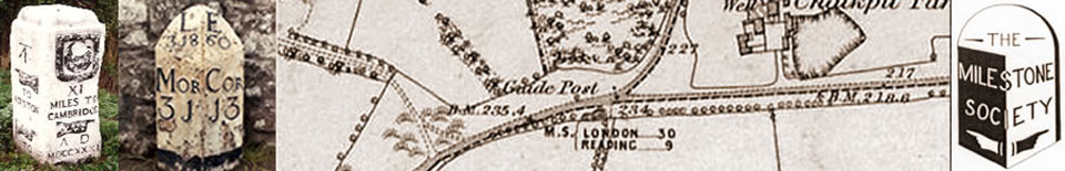
HIGHWAYS HERITAGE WALKS
Malvern – putting a spring in your step
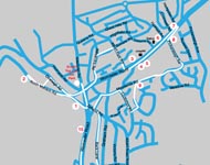
Walk Length: either approx 3.5 or 5.25 miles.
Grade: roadside; suitable for mobility-impaired.
Start: Link Top car-park, Newtown Road, Malvern Link: , off A449 Worcester Road.
Grid Reference: SO 774 471. Postcode: WR14 1NZ
Public transport: Bus No. 44, Worcester – Ledbury.
Railway Station: Malvern Link
Description
Malvern is situated in the scenic Worcestershire countryside beloved of the composer Edward Elgar. Popular in Victorian times for its therapeutic spa waters and numbering Florence Nightingale amongst its patients, the town retains a quiet charm with many fascinating roadside heritage features, including milestones and estate boundary markers.
Route Instructions
1. Stocks and Whipping Post, with spout.
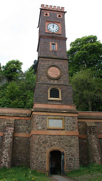
2. The Clock Tower - Geograph.
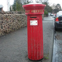
3. The Victorian Post Box.
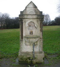
4. Temperance Fountain.
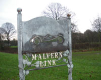
5. Morgan sign.
6a. Gas Lamp.
6b. Gas Lamp.
7. Hampden Fount.
8. Milestone, 7 miles.
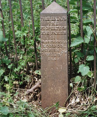
9. Clerkenwell Boundary Marker.
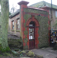
10. The Theatre of Small Convenience.
11a. Malvina Spout.
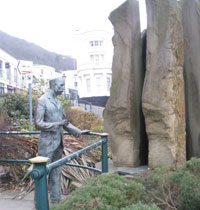
11b. Elgar Statue.

12. Milestone, 9 miles.
13. Fingerpost.
14.Foley Arms.
15. Milestone, 8 miles.
From the Malvern Link top car-park, cross Worcester Road to the side entrance of Holy Trinity Churchyard. Climb the steps to emerge on North Malvern Road. Turn left and cross the road to view the replacement Stocks and Whipping Post, behind a wire fence. The originals were used to punish local miscreants. 1 The Animal Pound was used to house strayed animals until their owners paid a fine to reclaim them. Continue up the road past the National School, Girls and Infant School on your right, to the Clock Tower. 2 The Church, schools and tower were financed by Charles Morris, a wealthy "Proprietor of Houses, of Portman Square, London" who used to spend the summer months in Malvern with his sister from the 1830s. He was a generous benefactor of the poor and set up a number of spouts for fresh water. The Clock Tower was originally a single storey Well Room built in 1836 and 'The Tank' was filled with 50,000 gallons of spring water from North Valley. In 1901, a further storey was added to the 'Tank' tower to support a new clock with four gas lit clock faces and a flag pole, to celebrate the coronation of Edward VII.
Retrace your steps and turn left down Pump Street. At the bottom is triangular Wedge House, whose sign shows a mouse and cheese. Turn right and follow Cowleigh Road and Trinity Road back to the start point by Link Top carpark.
Now walk down the main Worcester Road for about 300 yards (with the common on your right) and turn left into Alexandra Road. After 400 yards, look for a house named “Forli” on the left. Named after the early Italian painter of angel musicians, this was Elgar’s home from 1891 to 1899. Here his writings included Serenade for Strings and the Enigma Variations. Turn right into Somers Road and then right into Albert Park Road back to the main Worcester Road and turn left.
Note the rare fluted Victorian post box on the left. 3 This is one of three in Malvern made by Smith and Hawkes of Birmingham in 1857 and is still in use after 150 years. Prior to 1879, post boxes were painted green rather than red.
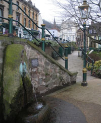
On the opposite side of the road is a drinking fountain. Around the Malvern hills there are over 80 springs, spouts, fountains and holy wells; some are natural springs flowing out of rock while others are surrounded by elaborately decorated structures. A complete guide may be found on www.malvern-hills.co.uk/malvernspa/ 4 This is the Temperance Fountain paid for in 1900 by the Malvern branch of the British Women’s Temperance Association.
Notice also the Malvern Link sign, 5 showing a Morgan car, by one of the few remaining British motor manufacturers. Morgans were first produced in Malvern in 1910 and are still highly prized today.
A new public toilet block may be found near Malvern Link Station; they were opened in Feb 2011, built by a property developer in exchange for a small piece of land owned by the Council.
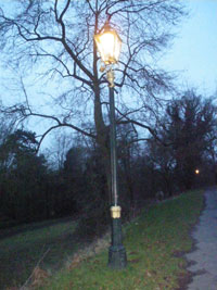
The elegant gas lamps on your left outside the station are in need of restoration; over 100, in a variety of styles, have survived in Malvern and contribute to the town’s Victorian ambience. 6 They inspired the gas lamp in the woods in “The Lion, The Witch and the Wardrobe” by C S Lewis, who attended school locally. Proceed downhill past Santler Count, a block of modern apartments on the corner of Howsell Road, named after the family who produced the first four-wheeled motor car in Britain in 1889. Their site later became the first Morgan factory.
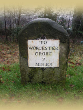
Continue to view the new Hampden Fount, a Millennium project nicknamed the Dumpling Fountain, at the corner of Hampden Road 7 then cross the Worcester Road, retrace your steps and pause at the United Reformed Church. Behind the railings is a milestone with the legend “To Worcester Cross 7 Miles”. 8
Because travel by road was slow and difficult and better trade routes were needed, Turnpike Trusts were established by Acts of Parliament from 1706 to 1840s. Groups of local worthies raised money to repair and later to extend the highway network. Users were charged tolls to pay for the work. The name ‘turnpike’ comes from the spiked barrier at the toll-bar. The A449 road through Malvern was turnpiked in 1725.
From 1767, mileposts were compulsory on all turnpikes, not only to inform travellers of direction or distances but to help coaches keep to schedule and for charging for changes of horses at the coaching inns. The distances were also used to calculate postal charges before the uniform postal rate was introduced in 1840. The directions were carved into the face of the original milestones but the soft stone soon weathered away. They were replaced by the current plated stones in the early 1800s.
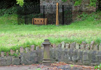
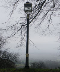
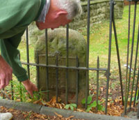
Turn left along Pickersleigh Road, then right into Meadow Road and follow this for quarter of a mile. Take the footpath on the right just past no. 87, turn right and cross the railway bridge. Follow Moorlands Road uphill for quarter of a mile and note more gas lamps. At the top of the Green take the first footpath on the left. There is a Clerkenwell Post behind the railings and a second one 50 yards down the path. 9 Cockshute Farm Estate was acquired in 1658 by Sir George Strode and he donated the income to the parish church and poor hospital of St. James’s in Clerkenwell, London. The posts were erected in the mid 1800s to mark the boundary of the estate. 25 were shown on a map of 1884 and many survive in gardens as the estate has been developed for housing. Follow the footpath down into Tennyson Drive and turn right, then continue to Cockshot Road. On the opposite side of the road, behind railings, is another Clerkenwell Post.
Turn right and follow Cockshot Road back to Moorlands Road. Turn left, past “Perrins House” with its attractive bell tower, now being re-developed, up to Graham Road. Note the ornate gate to “Davenham”, formerly the home of C W Dyson Perrins. Charles William Dyson Perrins (1864 –1958) took over the family business manufacturing Lea & Perrins Worcestershire sauce and became a Director of the Royal Worcester Porcelain Factory in 1891. He became Chairman in 1901 and supported the factory financially, ensuring its continuity from his own fortune, until it could be taken public in 1954. He was a great collector of illuminated manuscripts as well as Worcester china. Cross Graham Road and bear left into Bank Street. Note the painting of Canal Street on the right outside the Nags Head. On the left is a private house, formerly a W I Hall and previously a smithy.
At a small crossroads turn left and immediately right into Back Lane; follow this into Great Malvern, noting the many old coach houses now converted into private dwellings. On reaching the Prior’s Vineyard Spring, climb the steps into the Waitrose car-park and go past the store into Edith Walk. Turn right past the Theatre of Small Convenience, 10 Reputed to be the smallest commercial theatre in the world with a seating capacity of twelve, the theatre was converted form a Victorian public lavatory in 1999. www.wctheatre.co.uk The splendidly eccentric and talented owner entertains audiences with a variety of short productions. At the top of the road is the former Crown Hotel, now a Barclays Bank, where the Water Cure began.
Turn left and cross Church Road to the promenade below Belle View Terrace. http://en.wikipedia.org/wiki/Great_Malvern Here are the statue of Elgar leaning on the railings and the Malvhina Spout sculpture 11a & 11b If you go into Robson Ward’s yard, you can see the Bottling Works Spring showing the local geology.
The small friendly Malvern Museum, at the Priory Gatehouse, 1 Abbey Gateway, staffed by volunteers, is worth a visit; the history of Morgan cars is displayed. Check opening times: http://www.malvernmuseum.co.uk
For refreshments, there are plenty of coffee shops and cafes in this area and down Church Road.
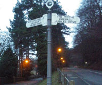
** For the longer walk, continue ¾ mile along Abbey Road, passing the Priory and with glimpses of the impressive buildings of Malvern College to your left, and turn left along the Wells Road to see the 9 mile stone 12 followed by an atmospheric row of gas lamps along the roadside, overlooking wide countryside views. Then turn back along the Wells Road towards Malvern. Walk between huge pine trees on each side of the road and you will soon come to one of the few fingerposts surviving in Worcestershire. 13 At the foot of the road up to the Wyche cutting, it dates from when Malvern was an Urban District and bears the maker’s name, the Royal Label Factory, Stratford on Avon. Continue along the Wells Road to Belle Vue Terrace.**
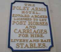
Return back to the Link Top carpark, northwards along the Worcester Road. The Unicorn Inn on your left has associations with CS Lewis and look for an interesting sign from coaching days on the Foley Arms. 14
There is small wall-mounted Victorian post-box on the left, just before Brays, originally a gentleman’s outfitters. Between the large houses are panoramic views. Further, on the right hand side, is the primrose-painted Montreal House where Charles Darwin used to stay with his family while his daughter Annie was treated with the waters; however she died at the age of 10 and is buried in the Priory churchyard.
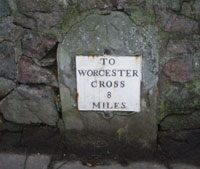
On the left hand side, at the third lamp-post past no. 59-61 Worcester Road, look for the milestone built into the wall, with the legend “To Worcester Cross 8 miles”. 15 Pass the old Police Station, now flats, on the right. There is a large thatched cottage on the left and in front of it is Penny Cottage, formerly a public convenience. Continue to Link Top car park.
We do hope you have enjoyed this historical stroll, compiled by the Worcestershire Group of the Milestone Society. The Society was established in 2001 to campaign for the conservation of milestones and other waymarkers, which are endangered by neglect, by vandalism and by casual destruction.
You can learn more about our work, including the publication “Finding Worcestershire Milestones” plus details of the c 9000 milestones in the UK, by visiting our website, www.MilestoneSociety.co.uk
While care has been taken to ensure the information above is accurate, the Milestone Society accepts no liability for any claim, loss, damage or injury (howsoever arising) incurred by those using the information provided. Please ensure that you wear suitable footwear and always carry a drink and a snack.
CLICK HERE to download a PDF to print out this walk