HIGHWAYS HERITAGE WALKS
Crossing the Pennines – the Yorkshire Colne Valley
Walk Length: approximately 5 miles
Grade: mostly easy with some moderate gradients up rough cobbled tracks; some roads. Not suitable for mobility-impaired.
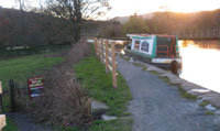
Start: : The Old Bank car-park in Slaithwaite, by the canal.
Grid Reference: SE 07850 13963 Postcode: HD7 5AR
Public transport: Bus 185 from Huddersfield to Marsden. Slaithwaite Rail station.
Additional roadside parking on Holme Lane near Shoulder of Mutton pub / St James’ church.
Description
Slaithwaite is an attractive village situated on the old route across the Pennines partially turnpiked by Blind Jack of Knaresborough and also on the Huddersfield Narrow Canal and the River Colne. Our route encompasses all three, and also a well-preserved pack-horse track and a pretty clough or valley.
Route Instructions
1 Cylindrical Milestone
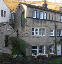
2 Weavers Cottage
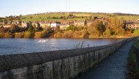
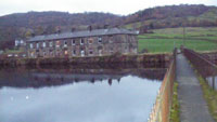
3 Slaithwaite Reservoir Walkway
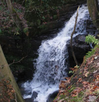
4 Waterfall
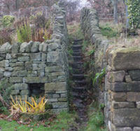
5 Merrydale Steps

6 Tyas Lane Setts
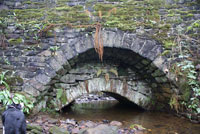
7 Look under the bridge
and see another bridge
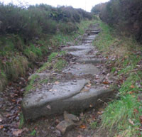
8 Causeway stones
9 The old packhorse track
10 Sandhills Cottages
11 Milestone 1, Olive Branch
12 Milestone 2, by Lingards Road
13 Lingard Steps
14 Turning Circle
15 Lock 31
16 Canal Milestone
17 Moonraker Barge
18 Packhorse Type Bridge
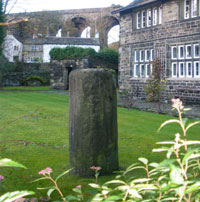
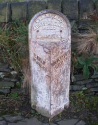
From the Old Bank car-park, behind the 1842 Free School, follow the path from the north-west corner (away from the canal), to the lawn behind the Elizabethan Manor House, the offices of Carter Jonas. Here you will find a large cylindrical stone, 1 reputedly a milestone from the Roman road from Chester to York through the valley. The Romans laid good metalled roads to move soldiers and supplies quickly across their Empire, marking every thousandth double-step with a stone, sometimes inscribed with dedications and distances. The Latin for thousand was ‘mille’ and the distance was 1618 yards; the eventual British statutory miles was 1760 yards, although ‘long’ miles also existed into the 18th Century. There are Roman milestones in museums at Leeds and Pontefract. After Roman times, roads developed to meet local community needs.
In the corner of the garden is the tiny lock-up or jail. Turn back up the cobbled drive to the road, Nabbs Lane, and turn left towards the 1840s railway viaduct, passing the ‘Silent Woman’, The Skelthwaite Arms in the TV series ‘Where the Heart Is’ and noting the weavers’ cottages on the right, 2 with narrow mullion windows and a take-in door. Continue up Holme Lane under the viaduct and turn right 3 along the side of Slaithwaite reservoir, one of ten built in the 1790s to supply the Huddersfield Narrow Canal. At the end of the walkway, turn left along the side of the reservoir and continue straight ahead on the path sloping up through the woods. You may wish to detour briefly (50m) to the left when you reach a mill pond, to see the waterfall that bypasses it. 4 The textile Mill built in 1790 was demolished in 1977.
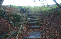
Returning to the path, continue upwards to Clough House Lane; as you pass some cottages on your right, note their privies and coal houses on your left. Follow the lane, bearing leftwards downhill to where the lane makes a sharp U-turn; look left over the bridge to the stream. Here was a Roman ford, part of the Roman road to York. Our walk continues through MerryDale: go through a gap on your right at the bridge and follow the path along the stream up this pretty clough, listening to the different sounds of the water as it passes over various types of stream bed. After about half a mile, you will reach a wall, a T-junction; the White Rose Forest walk is to the left, an easier route to Cop Hill, but our walk turns right. Look upwards on your right to see the remains of an earlier mill dam breached by a violent storm. Climb the path around Merrydale Fold. This was the home of a flamboyant Victorian herbalist called Richard Horsfall, nicknamed Merrydale Dick, who delighted in annoying the medical profession putting the letters ‘MD’ after his signature. Pass the other millpond on your left, climb the narrow stone steps 5 and follow the fence and stream, turning right on the tarmac drive. You will reach Tyas Lane 6 which was the pack-horse route from Halifax to Oldham; turn left down this lane, taking care because the setts can be slippery when wet. Crossing the bridge 7 over the stream you will begin to climb the old track, with its causeway stones, some of considerable size. 8 Goods were carried by packhorses though the Middle Ages and later, because the highways were not suitable for wheeled vehicles; usually a flagged stone causeway was the best surface, often with a sunken lane or holloway alongside, to permit passing. From 1555, the parishes and townships were made responsible for the maintenance of their roads. Individuals had to provide compulsory labour or a payment in lieu, the earliest form of ‘rates’ or council tax called the Composition.
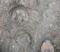
As you follow the track (Scout Lane) uphill, you may imagine hearing the bells of the packhorses.9 There is little room here for passing if two packhorse trains, perhaps laden with panniers of wool or salt, were to meet. Eventually you will reach Marsden Lane; follow this upwards to the Rose and Crown, at the summit of Cop Hill. The views from here are extensive and rewarding after the fairly arduous climb. The walk continues down Marsden Lane, with views across the Colne Valley opening up. If you wish to avoid a stretch of road, you can detour up Cop Hill Lane, a track to the right, rejoining the road lower down. Follow the road downhill for about half a mile, passing Slaithwaite Hall on its promontory. The manorial home of the Tyas family, it had an unrivalled view of the trade routes passing through the valley.
The original packhorse track bears right at the U-bend where Marsden Lane becomes Crow Trees Road. The track is steep but passable and leads under the railway bridge to Park Gate Road; for an easier route, follow Crow Trees Road under the railway bridge on Kettle Lane, and turn immediately right into Park Gate Road. Follow this (c 250m) to the footpath on the left leading to Sandhills Cottages and Sparth Reservoir. PigTail Bridge is a pleasant picnic stop and you may extend your walk to Marsden.
Our route continues down the footpath to the canal, in front of the cottages 10 to wooden footbridge no.53. Cross this, passing a disused mill and over its mill-ponds, down the steps and cross the bridge over the River Colne. Follow a dirt track leading from the Old Coach House uphill to the A62 Manchester Road. Turn left along the road.
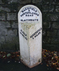
Because travel by road was still slow and difficult and better trade routes were needed, Turnpike Trusts were established by Acts of Parliament from 1706 to 1840s. Groups of local worthies raised money to repair and later to extend the highway network. Users were charged tolls to pay for the work. The name ‘turnpike’ comes from the spiked barrier at the toll-bar. The Manchester Road is part of the turnpike from Wakefield to Austerlands (near Oldham), commenced in 1759 and partly constructed by ‘Blind Jack’ Metcalfe of Knaresborough. It had been an important trade route from prehistoric times but was not suitable for wheeled traffic.
From 1767, mileposts were compulsory on all turnpikes, not only to inform travellers of direction or distances but to help coaches keep to schedule and for charging for changes of horses at the coaching inns. The distances were also used to calculate postal charges before the uniform postal rate was introduced in 1840.
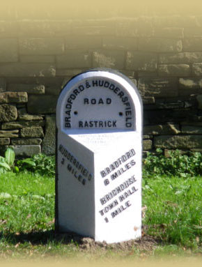
Opposite the Olive Branch restaurant, by the bus-stop, you can see a milestone. 11 600 of this type were manufactured at Brayshaw & Booth’s foundry at Liversedge in 1893, for the West Riding County Council. It gives the distance to Huddersfield as 6 miles; its companion at 5 miles is in better condition, 12 There is still an original First Turnpike 1760's milestone opposite Badger Gate on the B6107 Meltham Road; you can see a toll-house, now a florist’s shop, on the Manchester Road, Linthwaite, at the junction with Bargate.
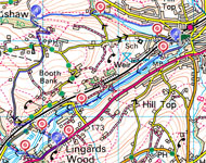
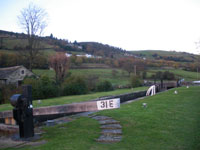
Take the footpath across the Olive Branch carpark to the left hand side, across a field and down some stone steps 13 through Lingards Wood, crossing a metal bridge over the Colne. Cross another field which is often muddy and follow the path onto the Canal towpath. On your left you can see a turning circle for barges.14 Turn right along the towpath, passing a Dartmouth Estate farm-worker's cottage, and lock no. 31E. 15
The Huddersfield Narrow Canal was begun with great optimism in 1794, to provide a link across the Pennines. Work camps were established at various strategic locations to house the numerous local labourers and craftsmen, the original navigators, later abbreviated to 'navvies'. A series of 74 locks along its 19.75 mile length raises the canal to a height of 645 feet above sea level, making it Britain's highest canal. The Standedge Tunnel proved a formidable obstacle and Thomas Telford was appointed in 1806 to finalise the work. The tunnel was officially opened in 1811, allowing through navigation for the first time between Huddersfield and Ashton-under-Lyne. However, by 1844 canal freight rates had fallen such that it was uneconomical to continue and the canal was sold to a railway company, who utilised it to build tracks still in use today. The canal was closed in 1944 and re-opened in 2001 through the efforts of local enthusiasts: see www.huddersfieldcanal.com
Our walk continues along the towpath towards Slaithwaite, about 1.25 miles. The tranquil water reflects the wooded banks, while the Colne bustles along on your right.
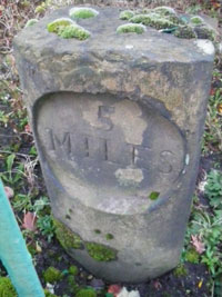
As you approach Slaithwaite, note the unusual Guillotine lock, used when there is insufficient space for a conventional one. Continue past Upper Mills; behind the green railings, amongst the vegetation, you can spot a Canal Milestone, engraved ‘5 Miles’, the distance to Huddersfield Aspley Basin. 16
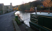
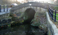
17 The canal features in the 'Moonraker' folk tale. The canal barges could carry valuable items such as casks of spirits and the boatmen might be bribed to lose the odd cask overboard, to be dredged out under cover of darkness. One moonlit night, the Revenue Officers disturbed the locals, who then claimed they were “only trying to rake the moon out of the water” ! Turn left over the packhorse-style bridge by the lock, 18 back to the car park. Slaithwaite has several pleasant cafes, pubs and an ice-cream parlour.
We hope you have enjoyed this historical stroll, compiled by the West Yorkshire Group of the Milestone Society. The Society was established in 2001 to campaign for the conservation of milestones and other waymarkers, which are endangered by neglect, by vandalism and by casual destruction.
You can find out more about our work plus details of the c 9000 milestones in the UK by visiting our website,
www.MilestoneSociety.co.uk
While care has been taken to ensure the information above is accurate, the Milestone Society accepts no liability for any claim, loss,
damage or injury (howsoever arising) incurred by those using the information provided. Please ensure that you wear suitable footwear and always carry a drink and a snack.
CLICK HERE to download a PDF to print out this walk